
Nature's
bounty
|
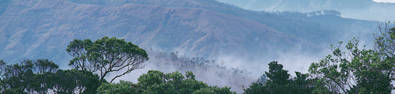
The unique geographical features of Wayanad, expressed in rugged mist covered
mountains and pastoral valleys, lend this northern district a peculiar charm and a delightful challenge for hikers and nature lovers. The last populous of Kerala's districts,
Wayanad is relatively backward and development has not appreciably improved the lives of the tribes who comprise a sizeable section of the population.
Wayanad's climate and geography make it ideal for the cultivation of coffee, tea, cardamom, paper and rubber. Plantations, especially of coffee, abound. Trekkers would like to head for the Chembra Peak, 18 km away, the Banasura Sagar Dam near Padinharathara, also 18 km away, as well as the Meenmutty waterfall, 40 km from Kalpetta. With picturesque hills, gurgling streams and lush vegetation, Lakkadi is one of the highest sports in
Wayanad, often subject to heavy rainfall. The beautiful natural fresh water Pookote Lake, 3 km from Lakkadi, is a favourite picnic spot. The District Tourism Promotion Council
organises boat cruises on the lake.
|
Places to visit
Manathavady:
At a height of nearly 500 m above sea level, 110 km from Kozhikode, is filled with coffee estates. It is historically important as the last resting place of Pazhassi Raja who valiantly fought the British. He was cremated here with full military honours. The Tomb of Pazhassi Raja and the park in his memory are reminders of this great ruler.
Thirunelly temple:
Sometimes called the 'Kasi of the South', is 32 km from Mananthavady. Believers say the idol of Vishnu was installed here by Brahma himself. Near the temple is the Papanasini whose waters, the religions believe, can wash one's sins away.
Pakshippathalam:
Close to Thirunelly is the brid-watching center The place can be reached only by trekking. A watchtower allows bird lovers to try and spot the different varieties of
birds, which come here.
Valliyurkavu Bhagawathi Temple:
This temple of Durga is known for the two-week long festival attended by hundreds of advises. In the past, devises were sold as bonded during this festival.
Kuruvadweep:
This 950 acers, uninhabited island on the eastward boun Kabani River is an ideal picnic spot. Apart from animals and birds, these islands have rich herbs, orchids and rare species of flowers. Kuruvadweep is 16 km from Mananthavady, will be delight for the eco tourists.
Sultan's Battery:
(pronounced in Malayalam as 'Sul-than Ba-the-ry'), 98 km from Kozhikode, was formerly known as Ganapathivattom. It derivers its present name from Tippu Sultan of Mysore who built a fort here in the 18th century. The remnants of the historic Pazhassi Raja fort can be seen at Panamaram, 29 km from Sultan Battery. This was Pazhassi Raja's stronghold until the fort was seized by the British in 1805. At Pulpally is a cave in which Pazhassi Raja took refuge until his capture. The Raja is also believed to have gifted a temple- the Mariamman Kovil - to the local tribes as a reward for their help in his fight against the British invaders.
Edakkal caves:
On the Ambukuthi hills are the two Edakkal caves, located at a height of 1000 m, natural rock-cut formations formed by a large split in a huge rock roofed over by other large rocks, all fixed in position through natural processes. These caves have been made famous worldwide for their ancient carvings and pictorial wall inscriptions of human and animal figures with peculiar head dresses and swastik forms and symbols. Archaeologists say the place was one of the earliest centres of human habitation. Dating to the prehistoric era of the new stone age civilizations, these caves can be reached from Ambalavayal, 16 km from Sultan Battery. The last two km to the caves have to be trekked. It is best to visit the caves in the morning.
Chethalayam waterfall:
Another beautiful spot accessible only by foot, is about 12 km from Sultan Battery, on the Pulpally main road.
Chembra Peak:
At 2100 m above mean sea level. Chembra is the highest peak in Wayanad and is an ideal area for trekking.
Lakkidi:
Lakkidi, the gateway to Wayanad, is situated 700 m above mean sea level, at the crest of the Thamarasseri Ghat pass. Lofty peaks, gurgling streams and luxuriant forests add magic to the journey up the winding roads ti this hill station.
Pookot Lake:
This perennial fresh water lake, nestled among wooded hills, is the only one of its kind in Kerala. Boating facilities, a children's park, a handicrafts and spices emporium and a fresh water aquarium are among the tourist facilities available here. The lake is 3 Km south of Vythiri Resorts.
Nagarhole Wildlife Sanctuaries:
This sanctuary in Karnataka State extends over an area of 634.39 Sq. Km. The park houses diverse species of plant and animal life. It is about 40 Km from Mananthavady. Visiting hours are 6 am to 8 am and 3 pm to 5.30 pm.
Begur Wildlife Sanctuary:
20 Km from Mananthavady has a wide variety of animals.
Muthanga Wildlife Sanctuary: 15 km from Sultan Battery. Contiguous with the protected area network of Nagerhole National Park and Bandipur. Tiger Reserve, Karnataka in the northeast and Mudumalai in the southeast, and falls under Project Elephant. The 345 Sq. Km. Muthanga Sanctuary is rich in fauna and flora. It is second largest in the state. Elephants roam freely here and tigers are sighted frequently. Various species of deer, monkeys, birds and so on are also found here. Trees and plants growing here are typical of the South Indian moist deciduous forests and West Coast semi evergreen forests. Best season to visit is June to October.
Bansura Project, Padinjarathara:
A mini hydel project with the largest earth dam in India and the second largest in Asia is being built here. A sprawling sanctuary and park with ever flowering trees are major tourist attractions. 25 Km northeast of Kalpetta.
Pazhassi Tomb:
The memorial of the Lionof Kerala - Veera Pazhassi Raja - who organised the guerilla warfare against the British East India Company, is situated at Mananthavady.The Pulpally cave is where Pazhassi took refuge until he was captured
by the British.
|
|
 |
 About Kerala
 |
|
About Kettuvallom |
|
About Houseboats |
|
About Backwaters |
|
|
| Kerala
Tour Operators |
|
|
| Fact
Sheet |
| Population: |
6,71,195 |
| Area: |
2131
sq km |
| Altitude: |
Sea level |
| Rainfall |
250
cm |
| Climate: |
Tropical
monsoon. Seasonally excessive rainfall. |
| Summer |
Max
Min
35°C 20°C |
| Winter |
35°C
20°C |
| Season |
Aug
to May |
| Clothing: |
Tropical
cottons |
|
|
|
|
Access
|
Air:
The nearest airport is at Karipur, Kozhikode.
Rail:
The nearest railway station is at Kozhikode.
Road:
Wayanad's headquarters. Kalpetta is linked by road to other towns in Kerala and there are frequent buses to Kozhikode.
Local Transport:
Private and KSRTC buses, Yellow-top and tourist taxis, Autorickshaws.
|
|
Picture Gallery |
|
|
|
|
|